

Key takeaways
- Magamba Nature Forest Reserve lies in Tanzania's West Usambara Mountains, near Lushoto in Tanga Region.
- It is a protected forest area managed by Tanzania Forest Services (TFS), not a TANAPA national park.
- TFS lists an area of approximately 9,283.9 hectares and places the reserve about 9 kilometres from Lushoto.
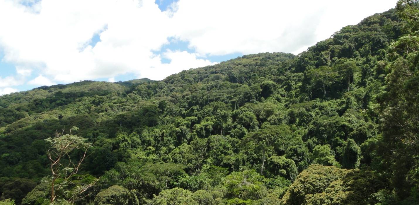
- The main attractions are montane forest, birdwatching, chameleons, butterflies, guided walks, viewpoints and historic landmarks.
- Established visitor materials describe the Grewal Trail, Kigulu Hakwewa viewpoint and Kwahondo Peak; current access, trail conditions and opening arrangements must be confirmed locally.
- A day trip from Lushoto is practical for most visitors with an appropriate walking route.
- Tanzania's 2025 Forest (Amendment) Regulations list an adult non-resident entry fee of TZS 40,000 per person per day for Magamba, with different rates for residents and East African citizens.
- Older US-dollar entrance figures found on some brochures are outdated and should not be relied upon.
- Wildlife sightings are not guaranteed. This is a forest-walking destination, not a Big Five safari.
Quick facts
| Official name | Magamba Nature Forest Reserve |
|---|---|
| Location | West Usambara Mountains, Tanga Region, Tanzania |
| Districts | Lushoto and Korogwe |
| Management authority | Tanzania Forest Services Agency |
| Officially listed area | 9,283.9 hectares |
| Nearest main town | Lushoto |
| Distance from Lushoto | About 9 km to the reserve area |
| Main activity | Guided forest hiking and nature observation |
| Other interests | Birds, chameleons, butterflies, viewpoints, historic sites |
| Historic trail names | Grewal, Kigulu Hakwewa and Kwahondo |
| Accommodation | Camping subject to approval; guesthouses and lodges in Lushoto |
| Day trip? | Yes |
| Non-resident adult entry | TZS 40,000 per day (2025 regulations) |
| National park? | No – a nature forest reserve |
The forest feels different almost immediately.
A few minutes earlier, the countryside around Lushoto may have been bright with cultivated fields and scattered houses. Now the light filters through tall trees. Ferns crowd the edges of the path, moss gathers on damp trunks and the sounds of the town begin to disappear.
You stop because your guide has heard a bird.
For a moment, nothing moves. Then a call comes from somewhere high in the canopy. You follow the sound, trying to find the bird among hundreds of leaves that all seem to be moving at once.
This is a different kind of Tanzania adventure.
Magamba Nature Forest Reserve has no famous lion prides or vast wildebeest herds. Its attractions are quieter: mountain forest, rare species, historic sites, views over the West Usambara landscape and the pleasure of spending a morning walking at a pace that allows you to notice things.
It also has a valuable conservation story. These mountains form part of the Eastern Arc, a chain of ancient forested highlands where geographic isolation has encouraged the evolution of remarkable plants and animals.
For travellers staying in Lushoto, Magamba is an accessible way to explore that natural heritage without undertaking a demanding multi-day expedition.
This guide covers the forest's location, its established walking routes, what wildlife you might encounter, the entry fees published in Tanzania's 2025 regulations, and how to plan a visit that respects both the environment and the people living around it.
What is Magamba Nature Forest Reserve?
Magamba is a protected area of montane forest in northeastern Tanzania. It forms part of the West Usambara Mountains, one of the mountain groups within the Eastern Arc system.
The Eastern Arc is important because its forests contain species with unusually restricted distributions. Some are found only in particular mountain blocks or limited areas of East Africa.
Unlike the open savannas associated with classic Tanzanian safaris, Magamba is shaped by altitude, moisture, forest cover and steep terrain.
Why does Magamba matter?
The reserve protects more than a scenic walking area. Its forests support biodiversity, contribute to water catchments and provide important habitats within a region where natural forest has experienced substantial pressure from land-use change.
Scientific research has documented changes in forest cover and the expansion of other land uses in and around Magamba over previous decades. That history gives the reserve a significance beyond tourism.
When you walk through the forest, you are entering part of a landscape in which conservation, water resources and the livelihoods of nearby communities are closely connected.
Is Magamba a national park?
No. This distinction matters for practical reasons. Magamba is managed by Tanzania Forest Services, while Tanzania's national parks are administered by Tanzania National Parks.
The two systems can have different entrance fees, permits, activity arrangements and visitor facilities. Do not assume that a national park ticket, TANAPA guide or standard game-drive package provides access to Magamba.
Why is it called a hidden gem?
The phrase is often used loosely in travel writing, but Magamba has a genuine advantage for visitors interested in hiking. It can be explored from Lushoto, a town that is already a useful base for experiencing the West Usambara Mountains.
The forest offers a relatively accessible introduction to an ecosystem many international safari travellers overlook. It is not necessarily empty, unknown to local residents or untouched by human activity. The appeal is the forest itself and the opportunity to understand it with enough time and attention.
How to get to Magamba from Lushoto
The most convenient approach is to arrange a visit from Lushoto with a local guide and confirm the correct reserve entrance before setting out.
From Lushoto town
TFS places Magamba approximately 9 kilometres from Lushoto. A historic reserve visitor leaflet describes an approach past Sebastian Kolowa University towards the reserve office.
However, that leaflet is older, and specific roads, gates and trail access arrangements may have changed. For this reason, use the route confirmed by the reserve office or your guide rather than relying entirely on an old map.
Can you walk from Lushoto?
A walking approach may be possible, depending on the part of Lushoto where you start and the trail or road used. But walking to the reserve and completing a proper forest hike are two different things.
If you want to spend most of your day exploring the natural forest, a prearranged transfer to the appropriate starting point may be more convenient. Ask your guide whether the planned distance includes the journey from town or only the walking inside the reserve.
From Mombo
Mombo lies on the main road corridor connecting parts of northeastern Tanzania. The route towards Lushoto climbs into the Usambara highlands. The historic reserve leaflet describes the Mombo–Lushoto journey as approximately 32 kilometres. Once in Lushoto, follow current directions to the reserve office or authorised meeting point.
From Dar es Salaam
TFS gives a broad road-distance figure of approximately 340 kilometres between Dar es Salaam and Lushoto. A same-day visit to Magamba from Dar es Salaam would leave very limited time for walking after the long journey. Staying overnight in Lushoto is usually the more practical option.
From Arusha or Moshi
Travellers beginning in northern Tanzania can reach the Usambara region by road, commonly using the corridor through Same and Mombo. The journey can be substantial, depending on your departure point.
Do not assume that the Lushoto forest visit can be comfortably added to a short Tarangire or Ngorongoro safari day. Plan it as a separate destination within a wider journey through northeastern Tanzania.
Transport comparison
| Starting point | Recommended approach | Planning consideration |
|---|---|---|
| Lushoto | Local transfer or a suitable guided walking approach | Confirm trailhead and total walking distance |
| Mombo | Road transfer up to Lushoto | Highland road and onward transfer |
| Dar es Salaam | Road journey, overnight in Lushoto | Long travel day |
| Arusha | Road journey through northeastern Tanzania | Allow substantial transfer time |
| Moshi | Road journey towards Same and Mombo | Better as part of a multi-day regional itinerary |
The exact drive times and any public transport schedules should be verified for the chosen dates.
The main Magamba forest trails and viewpoints
Magamba's walking experience is not one single route. Official TFS information identifies several viewpoints, historic features and nature activities. A detailed visitor leaflet prepared with conservation partners historically described specific trails.
Those names are valuable for planning, but the reserve office should confirm which routes are currently open, maintained and suitable.
Grewal Trail: forest, birds and small wildlife
The Grewal Trail is described in historical visitor material as a walk through dense montane forest, following mountain streams and areas of lush vegetation.
This is the sort of walk that rewards patience. You may hear birds before you see them. Butterflies appear in shafts of sunlight, and the forest floor offers a different world of ferns, leaf litter and small invertebrates.
Black-and-white colobus monkeys and Sykes' monkeys are among the animals mentioned in older reserve literature. None of these species can be guaranteed on a particular walk.
Best suited to: Birdwatchers, forest enthusiasts and visitors who prefer observing natural details rather than rushing to a distant viewpoint.
Check before travelling: Current trail condition, route length, whether the start remains accessible from the reserve office and whether a local guide is required for your selected activity.
Kigulu Hakwewa: forest views and history
The Kigulu Hakwewa viewpoint is one of the reserve's established visitor attractions. Spelling varies across sources, including Kigulu Hakwewa and Kiguluhakwea.
Historical visitor information places the lookout at approximately 1,850 metres, with views across the forest towards Lushoto. In clear conditions, this can be an appealing place to appreciate the shape of the surrounding landscape.
The area is also associated with a historic cave or tunnel linked in visitor literature to the German colonial period and the First World War. If the site is currently open, ask your guide to explain the history using verified local interpretation rather than assuming every popular story is historically established.
Best suited to: Visitors interested in panoramic scenery, gentle interpretation walks and local history.
Check before travelling: Current access to the viewpoint and cave, suitable walking or vehicle approach, structural safety and any restrictions on entry.
Kwahondo Peak: a more demanding mountain walk
Kwahondo, also written Kwehondo in some TFS materials, is another key landscape feature. An older conservation leaflet lists the peak at approximately 2,287 metres above sea level and describes access on foot from the reserve office or from a road crossing the area.
A hike towards the peak may be attractive if you enjoy a longer walk through highland forest. However, it would be unwise to promise a particular hiking time without knowing the current route and trailhead. A guide should assess your fitness, the weather, the condition of the path and whether the route is open.
Best suited to: Active walkers who want a longer mountain-forest outing.
Check before travelling: Current route, ascent, walking duration, guide arrangements and whether cloud or rain could affect conditions.
Jiwe la Mungu: a landscape and cultural landmark
Jiwe la Mungu means Stone of God in Kiswahili. TFS identifies the site as a stone with a footprint-like marking. Historical visitor material places it near Shume Nywelo village, northeast of the reserve, with views across the Maasai Steppe towards the Pare Mountains.
Its cultural or spiritual interpretation should be shared by people with appropriate local knowledge. Do not assume that a landmark's name gives visitors unrestricted access or permission to perform activities there.
Best suited to: Travellers interested in local interpretation, geography and viewpoints.
Check before travelling: Whether the site is part of the agreed route, current access conditions and any community permissions.
Grewal Pond, waterfalls and the skyline attraction
TFS also lists Grewal Pond, waterfalls and a skyline-style visitor attraction among Magamba's features. However, these should not automatically be bundled into every walking itinerary. Structures, access permissions and recreational facilities can change.
Do not assume a swimming pool, canopy walk or zipline is available because a promotional description mentions a skyline attraction or future tourism developments. Only book activities that are currently operating, permitted and supported by appropriate safety arrangements.
Trail comparison
| Route or feature | Main attraction | Best suited to | Must be confirmed |
|---|---|---|---|
| Grewal Trail | Montane forest, birds, streams | Nature lovers and birdwatchers | Current trail access and length |
| Kigulu Hakwewa | Viewpoint, landscape and historic feature | General visitors and photography | Site opening and cave access |
| Kwahondo Peak | Higher mountain landscape | More active hikers | Ascent, difficulty and weather |
| Jiwe la Mungu | Cultural landmark and views | History and landscape interests | Local permissions and transport |
| Grewal Pond or waterfall area | Water and forest scenery | Visitors wanting a varied nature walk | Safe access and activity permissions |
There is no verified current public trail timetable for all these options. Treat route durations offered by individual operators as proposals to confirm, not universal official times.
Wildlife, birds and rare species of Magamba
Magamba is a biodiversity destination. It is not a park where guides drive around searching for lions, elephants or buffaloes. The forest's wildlife often requires a slower style of observation.
West Usambara two-horned chameleon
One of the most fascinating animals associated with the West Usambara Mountains is the two-horned chameleon. Chameleons are easy to overlook because their colour and behaviour help them blend into vegetation. Finding one may require the knowledge of a specialist guide and considerable patience.
Never remove a chameleon from its habitat or handle it solely to take a photograph. This species and its relatives have conservation significance, making careful wildlife observation especially important.
Forest birds
The West Usambara forests support an impressive variety of bird species. Conservation literature for Magamba identifies birds such as the Usambara akalat, Usambara weaver, Usambara nightjar, Usambara eagle-owl, Fischer's turaco and banded green sunbird among the species of interest.
Some are difficult to detect. Their behaviour, altitude preferences and vocalisations can make specialist local knowledge especially valuable. A general forest walk may produce interesting bird observations without providing a long checklist of rare species.
For a dedicated birding excursion, ask whether your guide can identify species by call and whether the itinerary allows enough time to remain quietly in appropriate habitats.
Monkeys and small mammals
Black-and-white colobus monkeys and Sykes' monkeys are among the mammals historically reported from Magamba's forest trails. Their presence should not be presented as a guaranteed sighting. Other small mammals may remain hidden in dense vegetation. A quiet group that avoids excessive noise is more likely to enjoy undisturbed forest observation.
Frogs, insects and other small wildlife
Moist mountain forests support a remarkable variety of small animals. The broader West Usambara area is known for restricted-range amphibians and reptiles, while butterflies and other insects contribute significantly to the forest's ecological diversity.
Specialist identification is important. Some species can be confused with similar animals found in neighbouring forest fragments. If reptiles or amphibians are your main reason for visiting, request a properly qualified natural-history guide rather than expecting a standard cultural walking tour to provide expert species identification.
What about seeing animals at night?
Some forest animals are more active after dark. However, night walks should not be assumed to be allowed or included. Ask TFS and your operator whether a particular guided night activity is authorised for the selected area, and what safety and conservation conditions apply.
Wildlife expectations
| Interest | What you might experience | Important limitation |
|---|---|---|
| Birds | Forest birds and calls from the canopy | Rare species are not guaranteed |
| Chameleons | Specialist reptile observation | Requires patience and non-invasive viewing |
| Monkeys | Colobus or Sykes' monkey encounters | Animals move freely |
| Butterflies | Varied insects in suitable forest habitats | Activity changes with weather |
| Amphibians | Forest frogs in appropriate conditions | Species identification requires expertise |
| Large mammals | Not the main visitor focus | Magamba is not a Big Five safari destination |
History, culture and the human landscape around Magamba
Magamba's story is not only biological. The surrounding highlands have a long history of farming, settlement, trade and forest use. The Shambaa people are closely associated with the West Usambara Mountains, and visitors may encounter opportunities to learn about local livelihoods outside the protected forest. Those experiences should be organised with participating residents.
The historic German cave
A cave or excavated tunnel linked to the German colonial period is identified in both TFS materials and older Magamba visitor literature. The historical leaflet connects the site to the First World War.
A guided interpretation may help explain its setting and the history of the region. However, visitors should avoid treating the site as an open adventure playground. Only enter a historic structure if the responsible authority confirms that access is currently permitted and safe.
Communities and conservation
Forest protection affects nearby communities, and land-use decisions around mountain forests can be complex. People living around Magamba may depend on farming, water resources and other activities linked to the wider landscape.
A respectful visit acknowledges that conservation and livelihoods are connected rather than assuming tourism automatically benefits everyone. Ask your operator who provides the local guiding, how fees are handled and whether residents have agreed to any cultural visits.
Photography and consent
The forest is a natural photography destination, but homes, farms and cultural sites require additional sensitivity. Ask permission before photographing identifiable people or private property. Do not arrange unscheduled school or home visits as though they were ordinary tourist attractions.
Suggested half-day, full-day and two-day Magamba itineraries
The following itineraries are editorial planning models. They are not confirmed Wonders of Creation departures or TFS-approved timetables. Their purpose is to help you choose the amount of time that makes sense.
Half-day: forest introduction from Lushoto
Begin with a transfer from Lushoto to the agreed reserve entrance. After registration and guide arrangements, take a moderate forest walk suitable for your fitness level. Focus on birds, vegetation and small wildlife.
Depending on the current trail status, the guide might select part of a forest route or an accessible viewpoint. Return to Lushoto without trying to include several distant attractions.
Best for: Travellers with limited time and those who prefer a manageable introduction to the forest.
Full day: forest walk and viewpoint
A full day gives you more time to explore. Start early enough to enjoy the cooler conditions and allow pauses for wildlife observation. Your guide may combine a forest trail with an authorised viewpoint, subject to access and driving logistics.
Take a packed lunch or arrange a suitable meal stop where permitted. Return to Lushoto in the afternoon.
Best for: Hikers, birdwatchers and travellers who value a relaxed pace.
Two days: Lushoto and the surrounding Usambara landscapes
On the first day, focus on Magamba itself. On the second day, choose a separate attraction such as Irente Viewpoint, a guided village walk or Kisasa Waterfall, depending on what is open and what interests you. This is often preferable to attempting every excursion in one day.
The nearby attractions are not necessarily within Magamba Nature Forest Reserve and may involve separate permissions and fees.
Best for: Visitors who want both forest ecology and a broader impression of the West Usambara region.
Itinerary comparison
| Duration | Suggested focus | Main advantage |
|---|---|---|
| Half day | One forest trail or viewpoint | Accessible introduction |
| Full day | Longer guided walk with breaks | Better nature-observation time |
| Two days | Magamba plus a separate Lushoto-area excursion | Less rushed regional experience |
When is the best time to visit Magamba?
Magamba's montane setting is cooler and often more humid than Tanzania's lowland safari areas. The forest can be interesting throughout the year. However, the walking conditions change with rainfall.
June to September: often easier hiking conditions
These months are generally associated with a drier period in much of northern Tanzania. Trails may be more comfortable to walk, although mist and rain remain possible. The mountain air can feel cool, particularly in shaded forest or early in the day. Bring a warm layer even if you arrived from the warmer lowlands.
October to December: changing weather
The short-rain period can bring greener vegetation, wet leaves and slippery paths. Conditions vary each year. Photographers may appreciate the misty atmosphere, while hikers should be prepared for slower progress.
January and February: variable conditions
Some days can be relatively pleasant for hiking, but mountain weather remains changeable. Ask your guide about the condition of the selected trail rather than relying only on the general regional season.
March to May: wetter conditions
The longer rains may make forest paths muddy or slippery. Some roads and tracks could become more difficult to use. Wildlife observation is still possible, but a more flexible plan is advisable.
Seasons compared
| Period | Typical considerations | Recommended preparation |
|---|---|---|
| June–September | Often drier, cooler mountain conditions | Warm layer and comfortable footwear |
| October–December | Variable rain and mist | Waterproof clothing and flexible route |
| January–February | Mixed conditions | Check trail status before departure |
| March–May | Wetter paths and access challenges | Strong grip, rain protection and contingency plan |
For birdwatching or specialist herpetology, the ideal time may differ from the most comfortable hiking season. Discuss your particular interests with a qualified guide.
How much does it cost to visit Magamba?
Magamba has one important advantage over many destinations whose visitor charges are difficult to verify: Tanzania's 2025 forest regulations explicitly name the reserve.
The Forest (Amendment) Regulations, 2025, Government Notice No. 132, published on 21 February 2025, contain a specific entrance-fee category covering Magamba.
Official published entrance fees
The regulations list the following entrance fees per person per day:
| Visitor age | East African citizens/nationals | Residents who are not East African citizens | Non-residents |
|---|---|---|---|
| 18 years and older | TZS 5,000 | TZS 30,000 | TZS 40,000 |
| 5–17 years | TZS 2,000 | TZS 20,000 | TZS 30,000 |
| Under 5 years | Free | Free | Free |
Source: Government Notice No. 132 of 2025, Eighth Schedule, Part A(I), expressly covering Magamba Nature Forest Reserve.
These are the most recent Magamba-specific statutory entrance fees identified during this research. Confirm whether any later amendments, charges or administrative instructions apply to your actual visit.
Why older fee information is misleading
An older visitor leaflet lists entrance and camping charges in Tanzanian shillings and US dollars that differ substantially from the 2025 schedule. It remains useful for historical route descriptions and conservation background, but not for calculating a current visitor's entrance fee. Do not use an old US-dollar quote from that leaflet as though it were a current TFS tariff.
What about guiding and transport costs?
Entrance is only part of the total trip price. The relevant regulations also provide for guiding, vehicle, camping and other service charges. Your quotation may include:
- Forest entrance fees.
- A locally arranged guide.
- Transport from Lushoto or another starting point.
- Any separately permitted activities.
- Lunch or drinking water.
- Camping arrangements, where applicable.
- Vehicle and other relevant charges.
Ask whether each amount is per person, per vehicle or per group.
What does a Magamba hike cost in total?
A responsible operator should provide an itemised price for the specific visit. The total will depend on group size, transport, route, guide arrangements and any activities outside the reserve.
A full-day trip starting in Arusha will cost more than a locally arranged forest walk beginning in Lushoto because of the additional travel. Without a confirmed quote for the exact itinerary, a single all-inclusive price would be misleading.
Where can you confirm the fee?
TFS lists the Magamba reserve conservator's contact details through its official destination page. Before publishing a package price or collecting payment, the operator should confirm the entrance category, current fee collection procedure, guide arrangements and any additional charges.
Where to stay near Magamba
For most visitors, Lushoto is the most practical accommodation base. The town provides access to the reserve and other West Usambara activities.
Guesthouses and lodges in Lushoto
Lushoto offers a variety of accommodation styles, from relatively simple guesthouses to more comfortable lodges. Choose a property based on your budget, transport arrangements and the trailhead you intend to use. A guesthouse that is convenient for town activities may not be the closest option to the forest entrance.
Camping in Magamba
TFS lists camping among the reserve's tourism activities. Older visitor materials identify designated campsite areas, including locations associated with the Grewal Trail and Kigulu Hakwewa. However, campsite condition, availability, water access and facilities must be checked directly.
Do not assume tents, bedding or cooking equipment will be supplied. Camping inside a forest reserve requires the appropriate permission and compliance with current rules.
A practical accommodation question
Before making a reservation, ask: "How far is the property from the confirmed Magamba trailhead, and how will we reach it in the morning?" That question may matter more than a general description such as "near the Usambara Mountains."
Magamba vs other Usambara experiences
The West Usambara Mountains offer more than one type of visitor experience. Magamba is particularly suitable for forest ecology and walking. Other attractions around Lushoto focus more on landscapes, rural settings or waterfalls.
Magamba versus Irente Viewpoint
Magamba offers forest walking and biodiversity. Irente Viewpoint is associated with panoramic views over the surrounding escarpment and plains. A traveller whose main interest is forest birds and reptiles may prefer Magamba. Someone who wants a scenic viewpoint and a relatively shorter excursion could consider Irente.
Magamba versus Kisasa Waterfall
Kisasa Waterfall is a separate attraction in the Lushoto area. Some local operators offer longer walks combining forest landscapes and a visit to the waterfall. The precise route and whether it enters Magamba itself need confirmation. Do not assume that a ticket for the forest reserve automatically covers a waterfall excursion.
Magamba versus multi-day Usambara walking
Longer Usambara itineraries pass through villages, farm landscapes, forests and viewpoints over several days. These programmes are useful for visitors who want to explore the region more deeply. They may include sections around Magamba, but they are not equivalent to a single day within the nature reserve.
| Experience | Main attraction | Best for |
|---|---|---|
| Magamba Nature Forest Reserve | Montane forest, rare species and hiking | Birders, naturalists, hikers |
| Irente Viewpoint | Views over the escarpment | Landscape photography |
| Kisasa Waterfall | Waterfall and countryside walking | Active travellers |
| Multi-day Usambara trek | Villages, forests and highland landscapes | Longer walking holidays |
Conservation and responsible tourism
Magamba is part of a biologically important mountain system. Its forests have experienced pressure from land-use change, and conservation requires more than simply attracting visitors.
Stay on authorised trails
Walking off established paths can damage vegetation, disturb wildlife and increase erosion. Use permitted routes and follow the forest guide's instructions.
Don't handle or collect wildlife
A chameleon, frog, insect or flower should remain in its habitat. Avoid touching sensitive animals or moving them into a better photographic position. Collecting specimens may require special research authorisation and is not part of ordinary tourism.
Respect local knowledge and livelihoods
Tourism can create opportunities for guiding, accommodation and other services. But those benefits should be assessed rather than assumed. Ask operators whether local guides are paid fairly and whether any community encounters are arranged with the people concerned.
Avoid inflated sustainability claims
Using the words eco, green or responsible does not automatically prove that a trip benefits conservation. Better questions concern waste management, guide training, legal access, payment arrangements and the operator's actual practices.
Why forests matter to communities
Mountain forests help regulate water systems and support ecological processes that extend beyond their boundaries. That makes their protection relevant to farmers, towns and other people living in the surrounding area. A visit is more meaningful when the guide explains those connections instead of presenting the forest as isolated from human life.
Hiking safety and visitor rules
A guided Magamba walk is generally less demanding than a major Tanzanian mountain summit trek, but it still requires preparation.
Expect slippery terrain
Wet roots, muddy paths and steep slopes can make walking difficult. Wear suitable shoes with good grip. Avoid rushing downhill.
Prepare for weather changes
Rain and mist can arrive quickly in mountain environments. Carry waterproof clothing and protect essential belongings.
Use appropriate guidance
A local forest guide can explain the trails, identify species and help prevent visitors from accidentally entering restricted areas. Confirm the required registration and guide arrangements with the reserve office.
Take care around caves, structures and water
Historic caves, old visitor infrastructure and waterfall pools should not be treated as automatically safe. Do not enter closed structures or attempt swimming without confirmation that the activity is currently permitted and conditions are suitable.
Children and limited mobility
A short forest walk may suit some families, but not all trails are appropriate for young children or visitors with limited mobility. Ask about elevation changes, steps, uneven ground, toilets and rest opportunities.
Personal safety
Inform your guide about any relevant medical needs. Carry necessary medication, drinking water and emergency contact details. Mobile-phone coverage should not be assumed everywhere in the forest.
What to pack for Magamba
You don't need technical mountaineering gear for an ordinary short forest walk, but the right equipment makes the experience considerably more comfortable.
| Item | Why it helps |
|---|---|
| Walking shoes with grip | Muddy and uneven forest paths |
| Lightweight rain jacket | Rain and mist |
| Warm layer | Cool highland conditions |
| Water bottle | Hydration |
| Daypack | Carrying essentials |
| Binoculars | Birdwatching and canopy wildlife |
| Camera or phone | Nature photography |
| Spare battery | Long outings |
| Sun protection | Exposed sections and viewpoints |
| Insect repellent | Comfort in some habitats |
| Personal medication | Individual needs |
| Packed food | Longer walks, if appropriate |
| Small waste bag | Carrying out litter |
If your hike includes a specialist activity, such as bird photography or a long summit walk, ask the guide whether additional equipment is recommended.
Common mistakes to avoid
Mistake 1: Treating Magamba like a national park game drive
Magamba is a forest-walking destination. It should not be marketed as a place to expect lions, elephants or the Big Five.
Mistake 2: Following an old map without confirming the entrance
Historic visitor maps are useful background documents. They do not guarantee that every trail, bridge or gate is still operational.
Mistake 3: Using outdated entrance prices
The 2025 statutory schedule explicitly includes Magamba. Older fee tables should not be substituted for the current rules.
Mistake 4: Booking every attraction into one day
Kisasa Waterfall and Irente Viewpoint are separate experiences. Combining them with a substantial forest hike may be too ambitious.
Mistake 5: Expecting rare animals to appear on demand
Chameleons and forest birds are not guaranteed sightings. A quieter and more patient walk often provides the best experience.
Mistake 6: Underestimating wet terrain
A route that looks easy on a sunny afternoon may become slippery after rain. Your guide should adjust the walk to the actual conditions.
Mistake 7: Making unapproved cultural visits
Nearby villages, farms and homes are not automatically open to visitors. Arrange cultural experiences with willing local participants.
Magamba trip-planning checklist
Before choosing a date
- Decide whether you want a short walk, a full-day forest experience or a longer Usambara itinerary.
- Identify your main interests: birds, chameleons, botany, views or historical features.
- Choose a realistic duration for your fitness level.
Before booking
- Confirm the entrance and meeting point.
- Ask which trail is open and suitable.
- Check the exact guide and transport arrangements.
- Verify the current admission fees and additional charges.
- Ask whether lunch, water or camping services are provided.
- Confirm any special permissions for photography, research or activities after dark.
In the final few days
- Review the weather.
- Confirm your guide's contact details and pickup time.
- Prepare footwear, rain protection, binoculars and a daypack.
- If your planned walk includes a viewpoint or cave, confirm that it remains open.
During the walk
- Stay with your guide and follow reserve regulations.
- Don't collect plants or handle wildlife.
- Be patient with bird and reptile sightings.
- Take all litter out of the forest.
- Respect other visitors and local residents.
Questions to ask your Magamba forest guide
Before setting out, these questions can help you understand what the day will actually involve:
- Which reserve entrance will we use?
- Is the chosen trail currently open and maintained?
- How far and how steep is the walk?
- Do we need a separate guide or activity permit?
- Is Grewal Trail accessible on our travel date?
- Can we safely visit Kigulu Hakwewa or the historic cave?
- Is Kwahondo Peak suitable for our fitness level?
- Which forest birds or other animals are associated with this habitat?
- Are there any areas where photography is restricted?
- What happens if rain makes the trail unsuitable?
- Are meals or drinking water included?
- How are guide fees and park charges handled?
- Is camping available, and what equipment must we bring?
- What alternative walk would you recommend if our first choice is closed?
Wonders of Creation hiking experiences that include Magamba
Wonders of Creation Tours & Safaris already publishes several Usambara itineraries that include Magamba or the surrounding highland forests. These programmes offer starting points for enquiries, but their current availability and detailed inclusions need confirmation.
6 Days Hike to Mtae Usambara
The published programme begins with a walk through Magamba rainforest before continuing through villages and highland areas towards Mtae. It can appeal to travellers who want a longer regional hiking journey rather than only visiting the reserve for one day. Confirm accommodation, route changes, park fees and current transport arrangements before booking.
Explore the 6-day Usambara hike
4 Days Hike Mtae and Mazumbai
This itinerary includes a walk through Magamba forest and mentions a historic German-era trench or cave feature. It continues through other Usambara locations. Ask for a confirmed route map and clear information about which forest fees are included.
Explore the 4-day Mtae and Mazumbai hike
6-Day Usambara Herpetology Adventure
This specialised itinerary includes Magamba and other forest destinations in the Usambara region. It may interest visitors focused on reptiles, amphibians and their habitats. However, rare species sightings should not be guaranteed, and any night walks or specialist research-style activities require appropriate authorisation.
Explore the Usambara herpetology adventure
Which option should you choose?
For a simple forest visit, ask for a custom day hike beginning in Lushoto. For a broader walking holiday, consider one of the existing multi-day Usambara programmes. If specialist species are your priority, choose a qualified natural-history guide and confirm the exact itinerary, permitted activities and current conditions.
Final thoughts: the forest is the experience
Magamba doesn't need to compete with Tanzania's famous safari parks. Its appeal is different.
Here, the experience may begin with the sound of an unfamiliar bird or the discovery of a chameleon that would have remained invisible without a patient guide. A walk through the forest can reveal how closely biodiversity, water, farming communities and the history of the Usambara Mountains are connected.
The reserve is also accessible enough from Lushoto to become part of a wider journey through northeastern Tanzania. Choose a suitable trail, allow time to explore, check the current visitor arrangements and make the journey with someone who understands the forest.
You may leave without an extraordinary wildlife photograph. But you could come away remembering the quality of the light beneath the trees, the quiet of a mountain trail and the feeling that you discovered a different side of Tanzania.
Sources and further reading
- Tanzania Forest Services — Magamba Nature Forest Reserve
- Government of Tanzania — Forest (Amendment) Regulations, 2025
- Tanzania Forest Conservation Group — Magamba Nature Reserve visitor leaflet
- Wonders of Creation — Usambara Mountains
Always reconfirm the entrance, fee schedule, trail availability and any special activities before travelling.
Frequently asked questions
Where is Magamba Nature Forest Reserve?
Magamba lies in the West Usambara Mountains in Tanga Region, northeastern Tanzania. The reserve spans parts of Lushoto and Korogwe districts and is most conveniently visited from Lushoto.
How far is Magamba from Lushoto?
Tanzania Forest Services gives an approximate distance of 9 kilometres from Lushoto to the reserve. The actual distance to your chosen trailhead or reserve office may differ.
Is Magamba a national park?
No. It is a nature forest reserve managed by Tanzania Forest Services, rather than a national park administered by TANAPA.
What can you do at Magamba Forest?
Popular activities include forest hiking, birdwatching, wildlife observation, photography and visits to permitted viewpoints or historic features. Camping and certain other activities may be available subject to current arrangements.
How much is the Magamba entrance fee?
Under the 2025 Forest (Amendment) Regulations, adult entrance fees are TZS 5,000 for East African citizens/nationals, TZS 30,000 for qualifying non-East African residents and TZS 40,000 for non-residents per day. Confirm any subsequent changes before travel.
Do I need a guide to visit Magamba?
You should arrange your visit through the reserve office or a knowledgeable local guide and confirm the current entry and guiding requirements. This is particularly useful for unfamiliar or specialist nature trails.
Are there chameleons in Magamba?
Yes, the West Usambara forest region supports distinctive chameleon species, and TFS lists two-horned chameleons among Magamba's attractions. Sightings are not guaranteed.
Can you see monkeys in Magamba?
Older conservation literature identifies black-and-white colobus and Sykes' monkeys among the reserve's wildlife. Whether you see them depends on location, conditions and chance.
What are the best hiking trails in Magamba?
Established visitor materials describe Grewal Trail, Kigulu Hakwewa and the Kwahondo Peak route. Their current status, distances and difficulty should be confirmed with the reserve office.
When is the best time to visit Magamba?
The generally drier months from June to September are often convenient for hiking. The forest can be visited in other months, but rain may make trails slippery and affect road access.
Can I camp in Magamba Nature Forest Reserve?
TFS lists camping as a visitor activity. The exact campsite, permit, facilities and charges must be confirmed before arrival. Do not assume camping equipment or drinking water will be provided.
Can I combine Magamba with Irente Viewpoint or Kisasa Waterfall?
Yes, these are nearby attractions in the wider Lushoto area. They are separate destinations, however, and may need additional time, transport, guides and fees.
Related safaris and tours

Plan your trip with us
Our team in Arusha builds your trip around your dates, interests and budget – by form, email or WhatsApp.
Related guides
Facts last checked on .